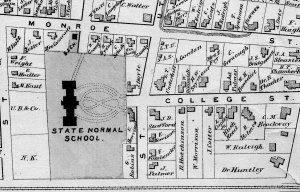
 Well, OK, there isn't actually an "X" marking the spot :-) What you're looking for on this map is where it says "State Normal School," which was our official designation when this 1872 street map was drawn. See, we really have been in this location for many years, 175 actually!
We will continue to post here about the history of our school, and there will be more campus events taking place as well as the college continues its celebration of this anniversary in 2011. Please do let us know of any aspects of the college history you would like to hear more about! Place a comment here, or email ccowling@brockport.edu.
(Shown here is a portion of a "plat" map, a map which shows the properties and names of owners in a given area. You will see properties and houses on the edge of what is now all part of Hartwell Hall's lawn. We have an 1872 and a 1902 plat map book for Monroe County in our local history collections.)
No comments:
Post a Comment